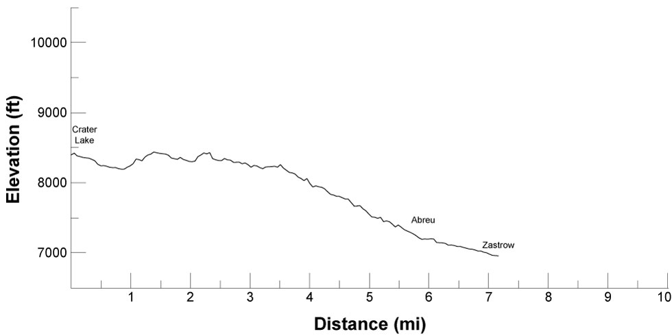

| Distance | 7.23 mi |
| Elevation Gain | 718 ft |
| Elevation Loss | 2,158 ft |
| Hiking Time | 3:13 |
| Starting Elevation | 8,399 ft |
| Ending Elevation | 6,959 ft |
| Min Elevation | 6,959 ft |
| Max Elevation | 8,438 ft |
Skirt along the north and east edges of Fowler Mesa, losing 200 feet and gaining 200 feet at a time, for about 3-3/4 miles. Then dive down 600 feet in just over a mile through six long switchbacks. Continue descending, more gently, for another mile to Abreu. Cross Rayado Creek and curve to the east, following an easy path to Zastrow.
Don't miss the cantina at Abreu for root beer and cards. Abreu also has Mexican homesteading and adobe brick making.
Water is available at Crater Lake, Abreu, and Zastrow. There are springs supplying water at Bear Caves Camp and Aguila Camp (about 1-1/2 and 2-1/2 miles into the route).
Itinerary 2 - day 11
Crater Lake: staffed camp with spar pole climbing, sawing competition, and company meeting campfire.
Abreu: staffed camp with cantina, Mexican homesteading, and adobe brick making. Showers may be available.
Zastrow: staffed camp with land navigation, geocaching, Dutch oven dessert, and Rededication to Scouting ceremony. Showers may be available